Tri-State Blizzard 2026: Snow Totals, Travel Bans, and How to Stay Safe
|
Once in a Generation. Or Close Enough.
The last time New York City sat under a blizzard warning was 2017. The last time New Jersey faced blizzard conditions in all 21 counties simultaneously was 1996. And the last time the tri-state area saw a storm of this magnitude was — depending on which official you ask — somewhere between 10 and 30 years ago.
This is that storm.
A nor’easter that rapidly intensified into what meteorologists call a ‘bomb cyclone’ has buried parts of New York, New Jersey, and Connecticut under two feet of snow and counting. Winds have hit 84 mph at Montauk — hurricane force. Visibility has dropped to near zero across much of the region. More than 400,000 customers lost power at the storm’s peak. Travel bans are in effect from NYC to Newark to Yonkers. NJ Transit is fully shut down. Schools are closed.
This guide has everything you need to stay safe — the complete snow totals by zone, the hour-by-hour timeline, every travel ban, transit update, power guidance, and warming center location in the tri-state area. Check back as we update throughout the day.
1. The Storm at a Glance
|
| Key Fact | Detail |
| Storm type | Nor’easter / bomb cyclone (rapid pressure drop off NC coast, moving NE) |
| Blizzard warning area | All of NYC, all of Long Island, all of NJ, coastal CT — until 6 p.m. Mon. |
| Winter storm warning area | Upper Hudson Valley, NW New Jersey, inland CT, much of New England |
| Total people under storm alerts | 26 million in tri-state; ~63 million from Tennessee to Maine |
| NYC declared states of emergency | Yes — Mayor Zohran Mamdani; travel ban in effect |
| NJ state of emergency | Yes — Gov. Mikie Sherrill; travel ban in effect statewide |
| NY state of emergency | Yes — Gov. Kathy Hochul; 22 of 62 counties |
| CT state of emergency | Yes |
| Schools open Monday? | NO — NYC public schools closed. NJ and CT schools closed across region. |
| NJ Transit status | FULLY SUSPENDED — rail, bus, light rail; no timeline for restoration |
| LIRR status | Suspended Sunday evening; no Monday early service; check MTA.info |
| NYC subway status | Reduced service; check MTA.info for current status |
| Major airports | JFK, LGA, EWR all experiencing major cancellations and delays |
| Power outages (peak) | 400,000+ East Coast; 57,000+ NJ; 123,000+ MA; 146,000+ MA total |
| Peak wind gust recorded | 84 mph at Montauk Point; 64 mph at Stony Brook; 60+ mph in Kew Gardens Hills |
| Snow rate (peak) | 2–4 inches per hour |
| Storm end time (NYC) | Approximately 2–3 p.m. Monday; eastern Long Island into late afternoon |
| First blizzard warning for NYC since | 2017 (approximately 9 years) |
| Historical comparison | NJ: first all-21-county blizzard conditions since 1996 |
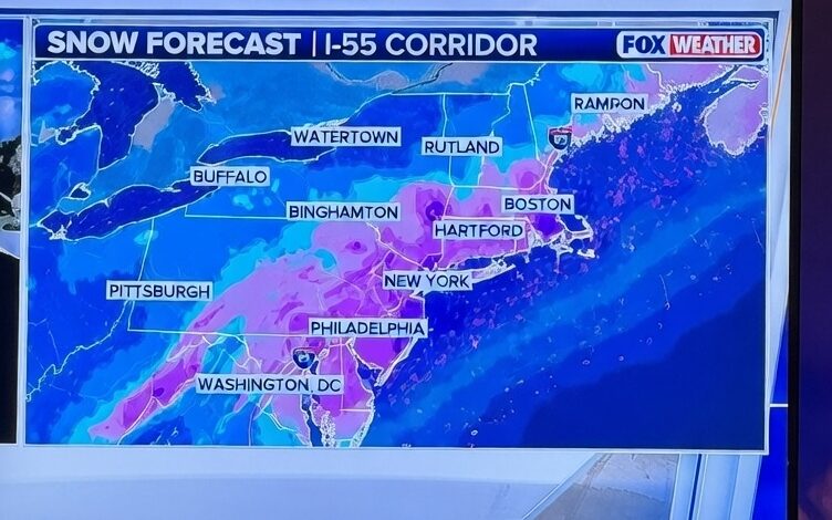
2. Snow Total Forecast by Zone: The Full Map
Totals vary significantly across the tri-state area. The heaviest snow falls south and east of NYC — closer to the ocean means more moisture, more snow. Here are the full projected and measured totals as of Monday morning.
| Zone / Location | Expected Totals | Alert Level |
| Long Island (east) | 22–28+ inches | Blizzard Warning |
| Jersey Shore (e.g. Freehold) | 22–30 inches | Blizzard Warning |
| New York City (all 5 boroughs) | 16–24 inches | Blizzard Warning |
| Brooklyn / Queens | Highest in-city amounts (16-24″) | Blizzard Warning |
| Long Island MacArthur Airport | 22.5 inches (as of Mon. morning) | Blizzard Warning |
| Coney Island | 16 inches (as of Mon. morning) | Blizzard Warning |
| Northern New Jersey | 12–20 inches | Blizzard Warning |
| Lower Hudson Valley / Westchester | 12–18 inches | Blizzard / Winter Storm Warning |
| Southern Connecticut (coast) | 12–18 inches | Blizzard Warning |
| Upper Hudson Valley / NW New Jersey | 12–18 inches | Winter Storm Warning |
| New London, CT / N. Kingstown, RI | 17 inches (as of Mon. morning) | Winter Storm Warning |
| Philadelphia | 12–18 inches | Winter Storm Warning |
| Boston and southeast New England | 18–24+ inches (historic possible) | Blizzard Warning |
Note: Totals are still accumulating as of publication. This table reflects projections and early-Monday measurements from NWS, CBS News NY, ABC7 NY, FOX 5 NY, and NBC NY. Final totals will be higher in many areas.
3. Complete Storm Timeline: Sunday Through Wednesday
The storm has multiple phases. Here is what’s already happened and what’s coming in the next 48 hours.
| Time | What to Expect |
| Sat., Feb. 21 | Pre-storm preps begin. NYC, NJ, NY declare states of emergency. SANIT loads plows and salt. NJ pre-treats roads. |
| Sun. noon–7 p.m. | Light to moderate snow begins across tri-state. Rain/snow mix possible in southern zones. Travel already deteriorating. |
| Sun. 7 p.m.–midnight | Snow rate escalates to 2–3 in/hr. Winds increase to 30–45 mph, gusting to 60+ mph. NJ mandatory travel ban in effect at 9 p.m. LIRR and NJ Transit rail service halted. |
| Mon. midnight–6 a.m. | Peak storm intensity. Snowfall rates of 2–4 in/hr in some areas. Whiteout conditions. Visibility near zero in Times Square. 57,000+ NJ power outages. Airports cancel hundreds of flights. |
| Mon. 6 a.m.–noon | Still snowing heavily. NYC blizzard warning in full effect. 17.4″ already on ground in Brooklyn by mid-morning. NJ travel ban extended to noon. Schools closed Monday across tri-state. |
| Mon. noon–3 p.m. | Snow tapers off in NYC and points north/west. Still snowing on Long Island and coastal CT. |
| Mon. 3–6 p.m. | Final flakes in most areas. Eastern Long Island still seeing snow. Total accumulations finalize. |
| Mon. after sunset | Temperatures drop below freezing. Roads, sidewalks, driveways refreeze. Wind chills fall to single digits and low teens. Stay off roads. |
| Tuesday | Cold but brighter. Cleanup underway. Travel improving but roads still hazardous. Avoid unnecessary trips. |
| Early Wed. | Possible minor additional snowfall — meteorologists stress it will be minor compared to this system. |
4. Travel Bans: What’s Closed Right Now
|
New York City — Full Travel Ban
- All bridges, highways, and streets closed to traffic from 9 p.m. Sunday through at least noon Monday
- Declared by Mayor Zohran Mamdani
- Exemptions: emergency vehicles, public safety, snow removal, healthcare workers, utility workers, public transit, media
New Jersey — Mandatory Statewide Travel Restriction
- NJ State Police issued mandatory overnight travel restriction effective 9 p.m. Sunday
- Extended through noon Monday (and potentially beyond — check NJ.gov for updates)
- Mikie Sherrill cited whiteout conditions, falling branches, and downed power lines
- Newark: Mayor Ras J. Baraka issued mandatory travel ban 9 p.m.–7 a.m. Monday (same exemptions as NYC)
Yonkers
- Travel ban effective 9 p.m. Sunday — issued by Mayor Mike Spano
Philadelphia
- Snow emergency declared starting 4 p.m. Sunday; 1,000 personnel and 800+ pieces of equipment deployed
Do not rely on this list as your only source. Check your local government’s website or official social media channels for the most current ban status in your specific municipality.
5. Power Outages: Who’s Affected and What to Do
The combination of wet, heavy snow and 60+ mph winds is exactly the recipe for widespread power outages. Trees loaded with snow snap under the wind. They take power lines down with them.
| State / Area | Peak Outages (Monday morning) |
| New Jersey (Jersey Central Power & Light) | 57,000+ customers — most of any single utility |
| Massachusetts total | 146,000+ customers (storm moved northeast) |
| East Coast total (peak) | 400,000+ customers |
| NJ utility response | 5,000+ utility workers deployed; 100,000+ already restored as of Monday morning |
To Report an Outage
- New Jersey: JCP&L — 1-888-544-4877 | PSE&G — 1-800-436-7734 | Atlantic City Electric — 1-800-642-3780
- New York: Con Edison — 1-800-752-6633 | PSEG LI — 1-800-490-0075
- Connecticut: Eversource — 1-800-286-2000 | UI — 1-800-722-5584
- Track your outage: PowerOutage.us for real-time maps
If Your Power Goes Out Now
- Keep refrigerator and freezer doors CLOSED — a closed fridge stays cold for 4 hours; a full freezer for 48 hours
- Never run a generator inside, in a garage, or near any window or vent — CO poisoning is a top storm killer
- Charge all devices NOW if your power is still on
- Move to warmest room in your home and gather in one room to conserve body heat
- Call 211 for shelter or warming center locations
6. Transit Status: MTA, LIRR, NJ Transit, Metro-North
|
NJ Transit
- All rail, bus, and light rail service SUSPENDED
- No timeline for restoration — NJ Transit CEO Kris Kolluri: ‘I want to do this in a way that’s safe for our customers and our crews’
- Plow trains deployed across system; crews working to restore power to switches
- 165 train stations being cleared of snow
- Heavy rail lines expected to return first — watch NJTransit.com and @NJTRANSIT on social media
LIRR — Long Island Rail Road
- Service suspended Sunday evening
- No Monday early-morning service
- Check MTA.info and the TrainTime app for restoration updates
- Long Island has recorded some of the highest totals — restoration may take time
NYC Subway
- Reduced service during the storm
- Check MTA.info or the MyMTA app for real-time status
- Avoid underground stations near coastal flood zones
Metro-North
- Check MTA.info for current service status — conditions vary significantly by line
Buses
- NJ Transit bus service suspended. NYC MTA bus service reduced — expect significant delays. Check MTA.info.
7. Airport Cancellations and Flight Disruptions
All three major New York-area airports are experiencing significant disruptions. More than 1,500 flights were canceled Sunday, and Monday cancellations are continuing.
- JFK International Airport: Major cancellations and delays — check FlightAware.com or your airline directly
- LaGuardia Airport (LGA): Major cancellations and delays
- Newark Liberty International (EWR): Major cancellations and delays
- Do NOT go to the airport without confirming your flight status directly with your airline
- If your flight is canceled: most airlines are offering free rebooking — check your airline’s website for their weather waiver policy
|
8. Why This Storm Is Different: The Bomb Cyclone Factor
This isn’t a typical nor’easter. It’s a bomb cyclone — and that distinction matters.
What Is a Bomb Cyclone?
A bomb cyclone — officially called bombogenesis — forms when a low-pressure system drops at least 24 millibars in pressure within 24 hours. The rapid drop acts like a pressure release, dramatically intensifying the storm’s wind speeds, precipitation rates, and overall destructive power.
This storm formed as a low-pressure system off the North Carolina coast on Sunday and intensified rapidly as it moved northeast — a classic East Coast nor’easter formation, but on steroids. The NWS described it as having a ‘comma’ shape, which is the characteristic signature of a mature, powerful cyclonic storm.
Why It Hits the Tri-State Especially Hard
The tri-state area’s position on the coast puts it directly in the zone where a bomb cyclone’s onshore winds are strongest and where moisture from the Atlantic supercharges snowfall rates. The difference between 8 inches and 24 inches of snow can come down to whether the storm tracks 50 miles east or west of its current path. This storm tracked east — meaning maximum moisture into the NYC metro.
|
9. Coastal Flooding: Jersey Shore, Long Island, and Connecticut
The wind-driven storm surge is creating serious coastal flooding alongside the snow — an unusually dangerous combination.
- Coastal flood WARNINGS in effect for all three states: NY, NJ, and CT
- Flooding of up to 2.5 feet expected during high tide cycles between Sunday night and Monday morning
- Jersey Shore communities have been hit hardest — Belmar reporter described ‘waves pounding the shoreline and snow blowing sideways’
- South Shore Long Island also facing significant flooding
- Do NOT drive on flooded roads — even 6 inches of moving water can knock a person down; 12 inches can carry away a small vehicle
- Check NOAA tide predictions at tidesandcurrents.noaa.gov for your specific location
NOTE: Coastal flooding occurs at high tide cycles. Even after snow stops, flooding risk may persist through the next high tide. Check your local coastal flood warning before approaching the shore.
10. The Wind Factor: Hurricane-Force Gusts Explained
Snow is one thing. This much wind combined with this much snow is something else entirely.
| Location | Peak Wind Gust Recorded |
| Montauk Point (elevated obs. site) | 84 mph — hurricane force (Category 1 threshold: 74 mph) |
| Stony Brook | 64 mph — hurricane force |
| Kew Gardens Hills, Queens | 60+ mph |
| Fordham, The Bronx | 60+ mph |
| Regional forecast gusts | 40–60 mph widespread through Monday afternoon |
| After sunset Monday | Winds finally fall below damaging levels |
Those gusts are not just uncomfortable. They are actively dangerous for pedestrians. A 60 mph gust can knock an adult off their feet. Wind chill at those speeds, combined with sub-freezing temperatures, creates conditions in which exposed skin can get frostbite in minutes.
The wind also significantly reduces visibility. Snow falling at 3 inches per hour becomes a near-total whiteout when combined with 40+ mph winds blowing the accumulated snow horizontally.
|
11. What Officials Are Saying
NYC Mayor Zohran Mamdani
|
NJ Governor Mikie Sherrill
|
NJ Transit CEO Kris Kolluri
|
Secretary of Homeland Security Kristi Noem
|
12. What Is a Blizzard Warning? (Explained Simply)
|
| Alert Level | What It Means |
| Winter Weather Advisory | Light to moderate snow/ice expected; travel will be hazardous but not impossible |
| Winter Storm Watch | Conditions are possible within 48-72 hours; prepare now |
| Winter Storm Warning | Significant winter weather expected; travel will be hazardous or impossible |
| Blizzard Warning | 35+ mph winds + visibility under 1/4 mile for 3+ hours; travel is dangerous or impossible; stay home |
The tri-state area is under a Blizzard Warning — the highest alert level. This is not a precautionary designation. It means conditions are already at or approaching blizzard thresholds right now.
13. How to Stay Safe During a Blizzard: 25 Steps
Before the Storm (if you still have time)
- Charge all phones, tablets, and backup battery packs to 100%
- Fill your bathtub with water — if pipes freeze, you’ll have water for flushing and basic hygiene
- Stock at least 3 days of food, water (1 gallon per person per day), and medication
- Move your car off streets marked for snow removal — check alternate side parking rules
- Download the MyMTA, NJTransit, and FlightAware apps for transit updates
- Know where your nearest warming center is (see Section 17)
During the Storm
- STAY HOME. Do not go out unless it is an emergency.
- If you must go outside: dress in layers, keep all skin covered, limit exposure to 15 minutes or less in high-wind conditions
- Watch for signs of frostbite: numbness, white or grayish-yellow skin, hard or waxy-looking skin
- Watch for signs of hypothermia: intense shivering, slurred speech, drowsiness, shallow breathing
- Keep driveways clear in stages — do not wait for the storm to end and try to move 24 inches at once. Take breaks.
- Clear snow from around furnace vents, exhaust pipes, and dryer vents — blocked vents can cause CO buildup
- Do not use generators, grills, camp stoves, or charcoal inside — carbon monoxide is invisible and deadly
- Keep at least one window cracked if using any supplemental heat source
- Check on elderly neighbors — hypothermia can develop even indoors in cold houses
For Shoveling Safety
- Shoveling wet, heavy snow is a leading cause of heart attacks during blizzards — take 10-minute breaks every 20 minutes
- Push snow, don’t lift, when possible
- If you feel chest tightness, shoulder pain, or shortness of breath while shoveling — stop immediately and call 911
- Wear sturdy boots with traction. Shovel-related falls cause thousands of ER visits each winter.
14. If the Power Goes Out: Complete Guide
Immediately
- Switch off or unplug major appliances — when power returns, surges can damage electronics
- Keep refrigerator and freezer doors closed. Fridge: safe for 4 hours. Full freezer: safe for 48 hours. Half-full freezer: 24 hours.
- Do NOT use your gas stove for heat — it produces CO and is a fire hazard
- If you have a fireplace, use it safely — keep damper open
- Group in one room and close interior doors to retain heat
Generators: Life-Saving Rules
- NEVER run a generator inside — not the house, not the garage, not any enclosed space
- Place generator at least 20 feet from any window, door, or vent
- If you hear a CO alarm or feel dizzy/nauseous, get out of the building immediately and call 911
- Let the generator cool before refueling — never add fuel while it’s running
If Your Home Gets Too Cold
- Call 311 (NYC) or your county’s emergency management office for warming center information
- Let faucets drip slightly to prevent pipes from freezing
- If pipes do freeze, do not use open flame to thaw them — use warm (not boiling) water or a hair dryer
15. Driving in a Blizzard: If You Absolutely Must
|
If you are an exempt worker who must drive during the storm:
- Clear ALL snow from your entire vehicle before moving — including the roof. Snow on a roof can become a deadly projectile when it slides onto other vehicles.
- Never warm up your vehicle in a closed garage — CO poisoning risk
- Drive significantly slower than the speed limit — recommended speed in blizzard is under 25 mph
- Increase following distance to 8-10 seconds (quadruple normal distance)
- Avoid cruise control on slippery roads — you need direct throttle control
- Pack an emergency kit: blanket, flashlight, hand warmers, water, snacks, shovel, sand/cat litter for traction, phone charger, first aid kit
- Tell someone your route and expected arrival time before departing
- If you get stuck: stay with the vehicle, tie something bright to the antenna, run engine 10 minutes per hour with window cracked to prevent CO, clear the exhaust pipe regularly
16. After the Storm: The Refreeze Danger
|
- After sunset Monday: Temperatures drop below freezing across the entire tri-state area
- Any road or sidewalk that was wet but ‘clear’ will become an ice rink
- Wind chills drop to single digits and low teens Monday night
- Tuesday morning commutes may involve significant black ice — treat roads with extreme caution
- Treat ice on your own walkways before it forms — apply salt or ice melt before sunset Monday
- A second minor snow event is possible early Wednesday — minor in comparison to this storm
17. Warming Centers Across the Tri-State
New York City
- More than 40 warming centers open across all five boroughs
- Call 311 (free, 24/7) to find the closest warming center to your location
- NYC has also increased outreach teams for homeless New Yorkers — if you see someone outside in need, call 311
- Code Blue is in effect: all available shelter space must be used
New Jersey
- Call 211 (NJ) for shelter and warming center locations in your county
- NJ has deployed emergency personnel statewide — 5,000+ utility workers already active
Connecticut
- Call 211 (CT) for warming center locations by town
- Check ct.gov/dss for shelter updates
Across the Region
- Libraries, community centers, and houses of worship in your area may also serve as warming sites — call your local municipality’s non-emergency line
18. Key Takeaways
- Blizzard warnings cover all of NYC, all of Long Island, all of NJ, and coastal CT until 6 p.m. Monday — the first for NYC since 2017
- Snow totals: 22-28+ inches on Long Island and the Jersey Shore; 16-24 inches in NYC; 12-18 inches inland. Still accumulating.
- Wind gusts hit 84 mph at Montauk (hurricane force); widespread 60 mph gusts across the metro
- Travel bans in effect for NYC, all of NJ, Newark, Yonkers — do not drive unless exempt
- NJ Transit is fully suspended across rail, bus, and light rail — no restoration timeline
- LIRR suspended; no Monday early-morning service; check MTA.info for updates
- More than 400,000 customers lost power at the storm’s peak across the East Coast
- Snow will taper off in NYC around 2-3 p.m. Monday; eastern Long Island into the late afternoon
- DANGER: Roads will refreeze after sunset Monday. Wind chills drop to single digits. Tuesday morning may be treacherous.
- Warming centers available across the tri-state — call 311 in NYC or 211 in NJ and CT
- NYC public schools CLOSED Monday; check Tuesday status from Mayor Mamdani
- This storm is NJ’s first all-21-county blizzard since 1996 — heed official warnings
19. Frequently Asked Questions (FAQs)
Is there a travel ban in NYC right now?
Yes. New York City Mayor Zohran Mamdani declared a travel ban on all bridges, highways, and streets effective 9 p.m. Sunday, February 22, 2026. The ban prohibits all vehicles except emergency, public safety, snow removal, healthcare, utility, public transit, and media vehicles. Check NYC.gov for the latest status.
Is NJ Transit running?
No. NJ Transit is fully suspended across all rail, bus, and light rail service as of Monday morning. There is no timeline for restoration. NJ Transit President Kris Kolluri said plow trains are operating and crews are working on switching infrastructure. Check NJTransit.com and @NJTRANSIT for updates.
Are schools open Monday in NYC, NJ, and CT?
No. NYC public schools are closed Monday per Mayor Mamdani’s announcement. Schools are closed throughout New Jersey and across most of Connecticut. Mayor Mamdani said he will make a decision about Tuesday at a later time.
How much snow has fallen so far?
As of Monday morning: Long Island MacArthur Airport has recorded 22.5 inches; Coney Island 16 inches; Brooklyn has approximately 17.4 inches on the ground; Freehold, NJ has 22 inches; New London, CT and North Kingstown, RI each have 17 inches. Snow is still falling in most areas. Final totals will be higher.
When will the blizzard warning end?
Blizzard warnings are in effect until 6 p.m. Monday, February 23, 2026, for NYC, Long Island, NJ, and coastal CT. Snow should taper off in NYC around 2-3 p.m. Monday, with eastern Long Island seeing snow into the late afternoon.
What is a bomb cyclone and why does it make the storm worse?
A bomb cyclone (bombogenesis) occurs when atmospheric pressure drops 24 or more millibars in 24 hours. The rapid intensification dramatically increases wind speeds, precipitation rates, and the storm’s overall power. This nor’easter formed off the North Carolina coast Sunday and underwent rapid intensification, explaining the extreme wind gusts and snowfall rates of 2-4 inches per hour.
Is there coastal flooding with this storm?
Yes. Coastal flood warnings are in effect for all three states — New York, New Jersey, and Connecticut. Flooding of up to 2.5 feet is expected during high tide cycles between Sunday night and Monday morning. The Jersey Shore, South Shore of Long Island, and coastal Connecticut are most affected. Do not approach the shoreline during or immediately after the storm.
What temperature will it be after the storm?
Temperatures will drop below freezing across the entire tri-state area after sunset Monday. Wind chills will fall to the single digits and low teens. This means all wet roads, sidewalks, and driveways will refreeze. A minor additional snowfall is possible early Wednesday but will not approach today’s totals.
Sources
All storm data, official statements, and reported figures are sourced from the following verified outlets as of Monday February 23, 2026.
- CBS News New York — Live storm updates and NJ Transit CEO interview (Feb. 22-23, 2026)
- ABC7 NY (Eyewitness News) — Wind speeds, Belmar coastal coverage, meteorologist Dani Beckstrom (Feb. 23, 2026)
- NBC New York — Live blog, blizzard warning expansion, snow totals (Feb. 22-23, 2026)
- NBC News (national) — 26 million under blizzard warnings; DHS Secretary Noem statement (Feb. 21, 2026)
- NPR — Northeast blizzard coverage; Mayor Mamdani statement (Feb. 22, 2026)
- CNN — Blizzard warning issuance; bomb cyclone explanation; state of emergency declarations (Feb. 21-22, 2026)
- CNBC — AP power outage data; storm accumulation tracking (Feb. 21-23, 2026)
- FOX 5 NY — Meteorologist Audrey Puente; snow totals; travel ban details (Feb. 22, 2026)
- Audacy / 1010 WINS — Blizzard warning timeline for NYC (Feb. 21, 2026)
- National Weather Service (NWS) / NOAA — Official alert data and meteorological analysis
This article is a living document and will be updated as the storm evolves. Verify all travel ban status, transit updates, and official guidance with your local government before making any decisions. Last updated: February 23, 2026, 10:00 AM EST.
Discover more from MatterDigest
Subscribe to get the latest posts sent to your email.